2013-12-29

They Shoot To Kill

Imagine, if you can, that you are walking through a quiet residential neighborhood in L.A.  Although most of the housing supply takes the form of mid-20th-Century dingbat style apartment buildings, there are a few old houses extant, here and there. As these neighborhoods go, it's reasonably peaceful and attractive, not least  because of the mature and leafy trees that line the sidewalks.  There are few if any outward signs of urban decay, crime, or other social ills.  As you read this, imagine peppy-go-lucky 1960s sitcom theme-type music playing in the background.

There's an attractive church in the neighborhood, Saint Mary in Palms. 


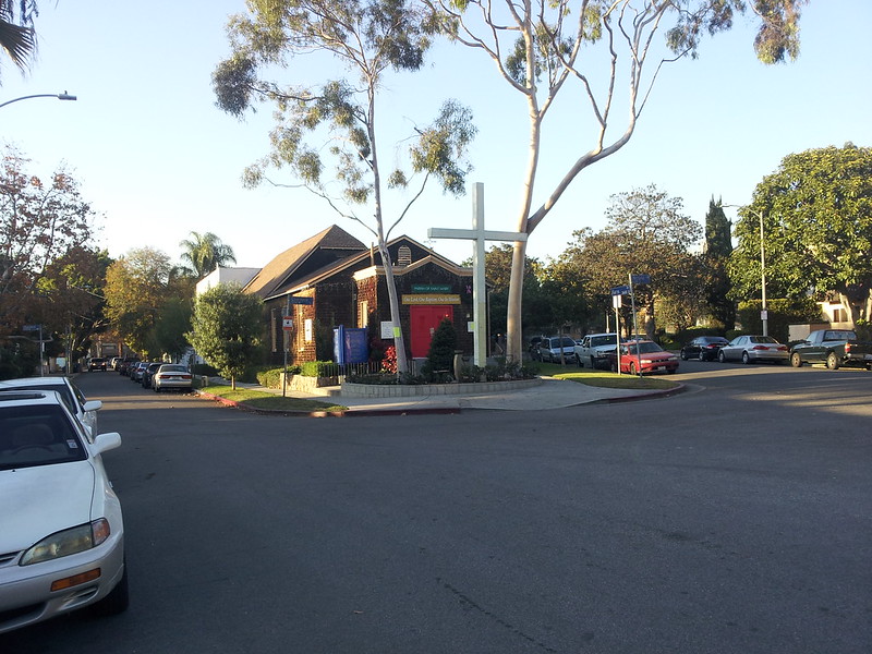
I like the way it's sited on the gore point of a three-way intersection, giving it a sort of East Coast small-town feel. 


If this were New York or Boston, this little intersection might well  have some charming appellation like Saint Mary Square; after all, what is Times Square really but the intersection of Broadway and Seventh?  But we don't generally name things in this town unless it's either absolutely necessary or someone's generosity is in need of acknowledgement.  That's L.A. for you.  Instead of  Saint Mary Square or Tabor Triangle we have The Intersection Of Watseka Avenue And Faris Avenue Where That Church Is. 

Mature broadleaf trees shade the quiet streets...


and many of the extant single-family houses exhibit considerable variety in their design. 


You walk further, continuing to hear 1960s sitcom music in your head, and you come across another church, belonging to the Seventh Day Adventist Reform denomination.   


There's nothing particularly interesting about the siting or architecture of this house of worship, but around the corner you find this curious holiday display.


Let it flock, let it flock, let it flock!


First of all, the snow.  Can I say one thing about it?  Fake snow on a sunlight-dappled Southern California Lawn is the sort of thing that gives this city a bad name.  Secondly, the characters are worth a closer look.  Charlie Brown, Linus, and Snoopy stand forth for the renowned comic strip and animated cartoons, although only Snoopy looks particularly happy--ironically so, as we'll see.  I don't think the kid bundled up in the pinkish coat and hat is a Peanuts character--South Park, maybe?  And in the background is little Cindy Lou from The Grinch Who Stole Christmas, with Frosty The Snowman rounding out the scene.  Clearly, this person has issues with plot continuity, and it's even possible that there's some sort of copyright violation here, what with the random juxtaposition of all these characters.

But whatever; whoever lives here certainly seems to be getting into the spirit of the season, we have to admit. 

Still imagining the sitcom sound track, now perhaps with Christmas special episode touches included, you stroll further and find this rather foreboding sign.


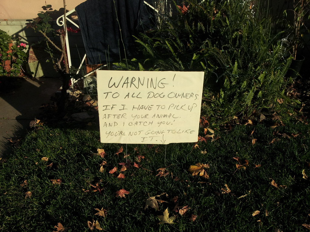
Dog owners are warned!
 
In case it's hard to read this on whatever screen you are using, here's the copy:

WARNING! 
TO ALL DOG OWNERS   
IF I HAVE TO PICK UP 
AFTER YOUR ANIMAL 
AND I CATCH YOU 
YOU'RE NOT GOING TO LIKE 
IT. 

No wonder Charlie Brown looks so miserable.  He's counting the seconds until he can get Snoopy out of here.  What do you think will happen to Charlie Brown if the occupant of the house does catch him omitting to clean up after Snoopy?  Will the resident come out and shout angrily while waving his fist in the air?  Will Charlie Brown get captured on a webcam and reported to the authorities?  That could be, but not judging from what we see a few paces further on:


The sign on the lower left is particularly grim, not to mention callous in the disregard it exhibits for the neighbors, for example the church.  What's more, Sunday morning -- or in this case I guess it would be Saturday morning--churchgoers have to pass by this as they enter and leave the church grounds.


Y'all can just go rob someone else! 


Granted, these signs are addressed to anyone who may be thinking of committing robbery, although those who may be considering mere burglary would be unwise to assume that the occupant of this property is aware of the legal distinction between burglary and robbery.  On the other hand, while the householder almost certainly comprehends the difference in magnitude between robbery and canine elimination free-range enabling, he clearly has a temper.  "Move along, as quickly as possible" is what Charlie Brown's closest friends would advise.

Just outside the right frame of the picture above is the parking lot for the Adventist church, because its property wraps around the one occupied by the gun aficionados.  I had to make sure, by checking the county parcel database, that the two parcels are indeed separate, and this was a good thing.  It would have been disheartening to learn that the Adventists had abandoned their pacifist principles. 


It turns out that this isn't the end of it. The blocks in this neighborhood are oddly shaped, so only a little further on is yet another corner.   On this spot is the house of another firearms expert, proclaimed as follows:


The wording here is considerably more restrained.  Be that as it may, here in one small residential block we have multiple signs warning burglars and robbers that they may be shot, and of those, two seem to be aiming the gun at any and all onlookers.   I have to wonder what happened at these two houses, almost next door to each other, and next door to a church yet, that these signs are considered necessary.  A good security system and burglar alarm would probably be more effective.


2013-08-22

Borat, Slack, Tame. And oh yeah, Emily.

From the last post's footprints in cement, we segue to painted graffiti art. 

A few weeks ago I came across this wall-ful of skillfully painted graffiti.  I have no idea who created it, nor do I expect to. But it would be nice to know the inspiration behind these tags.  These pictures weren't taken in a gang area, so I think we can rule out that as an answer.  Nor is it likely to be the work of typical of juvenile taggers, since it's clearly much better done than that.  I think what we have here is simply some person or persons unknown who decided to take advantage of a recent demolition.  I frequently pass by here myself, and can't remember what used to be here; presumably it was nothing terribly interesting.


As much as anything it was the name BORAT that got my attention. I thought the Sascha Baron Cohen's performance in the film was very funny, rising as it did to heights of surrealistic slapstick lunacy.


Borat


 Impressive here are the background color, shadowing, and a great use of yellow and light blue, even though that's hardly my favorite color combination.  He's signed it "BORAT 2013" and it wouldn't be surprising to find other examples of his work around town. 

Next up is "TAME"...


It's all right, I don't think he's dangerous.

And then "SLACK".  I particularly like how the serifs on the S are made to be almost as large as the constituent strokes of the letter itself.


There are a couple more names at the far right.


I haven't been able to decipher the last one--is it QHTM?--  but I have to give a nod to "Emily".  Everything else on this wall has been carefully painted with color, background, and shading effects, but apparently Emily just wanted to say...


Her name is Emily


 "Hi, my name is Emily and I was here, too!"  The plain lettering and the "i" dotted with a heart are endearingly humorous when contrasted with the bold statements made by the other painters.  Furthermore, she's almost certainly the only one who used her real name.  

The other artists, though, have decided to make new names for themselves. 

UPDATE: Emily obscured!


I checked back here a few days ago, and found there was some new work. 


 SLACK has redone his bit with considerably more flourish, and a few newcomers have been here too--"TOENOSE" or something like that; meanwhile the new, orange writing to the right lies just beyond my ability to decipher it.  I suspect otherworldly visitation as a possible provenance.  Almost obscured by these bold expressions of -- ah -- whatever it is they are trying to express, is another name which must have been Thunder Prism.  I didn't expect Emily to last long on this wall, but now she's been obliterated, all except for the tail of her 'y' and the bottom stroke of her 'E'.
 

2013-08-05

Rancho Park Laetoli

In the very living wet concrete, a small party of Homo Sapiens left their tracks. Careful analysis of the available evidence places this event definitively in the Early Middle Elvis Epoch.  That is, it was after he had left Sun Records for RCA, but before he enlisted in the U.S. Army--which pins it down to 1957.

A few particulars are suggested by the evidence.  First of all, we seem to have here a family, comprising the parents and two daughters.

First, the mother:


And little Carol, the youngest:


Older sister Wendy:


and Dad, apparently known to friends and family as Coop:


 They stopped here in 1957 and carefully left the impressions of their right feet.  One of the youngsters left her right hand print too, just above the date: August 1957.  


,


What does this astonishing discovery tell us about the life of these humans of the remote past, so long ago?  Besides their erect posture and the highly evolved structure of their hands,  it does seem that both parents have slightly  flat feet, possibly due to standing up all day.  Possibly they were teachers, although presumably not at the Catholic girls' academy across the street.  Bea's foot seems almost as big as Coop's, and wider, but that could just be an accident with regard to how she made the impression in the wet concrete.  Or it could have been a later distortion, made before it had set. 

The Early Middle Elvis Epoch was in many respects a stultifying one with respect to the mainstream culture.  Rock music had gotten rolling, but in the eyes of many it was just a trend already on the wane, and in any case of interest only to teenagers. This was a straitlaced era, in which you did not write graffiti or leave footprints in wet pavement. There was no time for such foolishness, because the Communist threat was everywhere. You didn't want to stand out from the crowd, especially by defacing public property, and most especially as a family, all in one place and at the same time.  Just think of the children!  What kind of example does that set? 

Well, I think it sets an excellent one.  There's nothing wrong, in my opinion, with bending the rules a bit in a spirit of innocent fun, especially with one's kids. Bea and Coop could be great-grandparents by this time--or at least grandparents, and it's gratifying to think that today they can bring their grandchildren to this spot and show them that there were some fun loving and free spirited adults--parents, yet--even in the Early Middle Elvis Epoch.  On the other hand, whether it's 1957 or 2013, there are always some self-righteous prigs who consider themselves personally affronted by such innocent pranks.  They should get a life. 

To Bea, Coop, Carol, and Wendy: If you read this, I don't think anyone will come after you for your wet cement graffiti act.  And thank you from the bottom of my heart for brightening my day.

The subject of urban sidewalk archaeology also came up a couple of years back, right about here.

2013-07-24

P Is For Palms


Palms Women's Club (detail, showing the unfortunate addition of faux-flagstone siding)

(Note: In the text below there are a number of passages suggesting that one building or another is likely the oldest building in the neighborhood, or close to it.  As of 2015-09-14 new information--to me, that is--has come to light regarding a couple of still older buildings.  This post will be revised accordingly and republished in the near future, but for now this disclaimer will have to do.)

Today Palms is an area of Los Angeles which is typically defined by what it isn't.  It's not Cheviot Hills or Culver City, and it's not Mar Vista. And although its Westside credentials are undisputed, it isn't properly part of West Los Angeles because it's on the wrong side of the 405.  For historical reasons its boundaries have always been uncertain, and even today various sources like the L.A. Times and the Palms Neighborhood Council disagree on the exact boundaries--sometimes virtually on a house-by-house basis.  Many local place names in Spanish have definite articles--La, El, Los, or Las and that might have inspired the mostly Anglo and Midwestern settlers who named this place The Palms.  In English this sort of thing works when the name doesn't otherwise mean anything, like The Bronx or The Dalles.  But with common nouns like palm, especially in Southern California, not so much.  In researching the LAPL photo database for this blog post the first hits that came up were the palm tree designs that used to grace the walls of the Cocoanut Grove! 

Northeast Palms, from the 1910 Sanborn map


 Researching the history of L.A. often takes superior dedication when it comes to districts that were once considered remote suburban villages.  The maps from different years sometimes show multiple name changes for the same street, for example Cyprus Avenue in the 1910 map


1928 street map from the David Rumsey Collection
 which had become Stinson Avenue by 1928, and eventually Palms Boulevard.  Palm Ave became Featherstone before eventually becoming Rose Avenue.

Before it was swamped by the spring tide of post WWI urban sprawl, Palms stood in the center of the agricultural district where it had been founded in the 1880s. The early 1900s found it a thriving community of about a thousand inhabitants, boasting the assortment of small businesses typical of farming villages in that era. There was also the Villa or Palms Villa Hotel; the archives of the Los Angeles Times indicate it had been operated by one M.J. Howard, beginning no later than 1890. Again like many small towns, there were no saloons, although some enterprising businesspeople did their best to quench local thirsts by operating just outside the  town limits.  The local elementary school had already been operating for some years and around this time moved to its present site on the southeast corner of Palms Boulevard and Motor Avenue. It's likely that the little community boasted a telephone exchange as well, but available sources are silent on this. In addition to all these amenities there was the Palms train station, served by both Southern Pacific and Pacific Electric trains--steam and electric traction respectively.


This was one of the very last Pacific Electric routes and passenger service was finally ended altogether in 1953. Ten years later, thanks to local preservation advocates, the old station was moved lock stock and barrel to Heritage Square, near Pasadena, where it lives on as a museum piece.  Today the local Metropolitan Transit Authority has already brought passenger service back to the Expo route as far west as Culver City, and by 2015 it is supposed to be in service all the way to Santa Monica.  The new Metro station is currently under construction and stands about 100 yards east of where its predecessor stood.


New Palms Station under construction at Palms and National

The old railroad bridge partially visible behind the new eastbound bridge is said to be the only extant one from the old railroad which will be incorporated into the new transit line.  In line with the MTA's rather drab standards when it comes to naming stations, plans originally called for this one to be called Palms/National.  We can all be grateful for the Palms Neighborhood Council which persuaded the MTA to name it simply Palms. Why should we care? We care because L.A. doesn't tend to be a city of named districts, except for a few formerly independent cities like Hollywood and Palms.  A good place name is more than just a label; it simultaneously reflects and reinforces the character of a location.  

Palms was annexed by Los Angeles in 1915, but continued to maintain a distinct personality as a community within the city.  The Palms Chamber of Commerce continued its activities, and the next few years saw the founding of two Masonic lodges and the Palms Women's Club, which had its clubhouse on Palms Boulevard.  Incidentally, the name of this thoroughfare has been changed at least twice: A Sanborn map from 1910 shows it as Cypress Avenue, and on a 1928 street map of L.A. it's Stilson Avenue.  In fact, the history of this area is rife with street name changes, sometimes complicating matters with regard to historical research.


Palms Women's Club
The building's front was emblazoned with a large letter 'P' whose style and color have evolved through the years, and still recalls the building's original occupants although it has been vacant for many years.  The PWC was active at least into the 1960s, according to available sources.  Today it's vacant and it's for sale, and it will be interesting to see what happens.  Developers are betting big on the future growth and demand for apartments in this area, but this particular slice of ground doesn't seem too well suited for that.  Recently in an apparent effort to spruce the place up, the door was replaced and painted red.  For some reason this brings out the private residence-like character of the place; it doesn't really seem like anything else.


Early Commercial Development


Just as it is today, in the beginning the commercial core of Palms was along Motor Avenue (then Fourth Street) particularly near the intersection with National Place.  Other important thoroughfares included Overland Avenue and Palms Blvd, which was then called Stilson Avenue.  According to public records, 1912 saw the construction of what must be the earliest extant commercial building in Palms. The structure displays a number of architectural features typical for the era, like the transom windows and the  decorative exterior touches that seem to emanate from the building's basic fabric of bricks, rather than being merely plastered on.  Traditional revivalist details, like classicist pilasters, plinths, or capitals, are entirely absent.


1912 building on Motor Ave., likely the oldest extant business building in Palms


Although currently vacant, the building has recently housed a hairdressing salon.  The building next door houses the offices of a consulting structural engineer; one can't help wonder if the 1912 structure has also been used for some sort of engineering or design work.  The expansive windows seem calculated to let in the most light possible for the detailed work those fields entail.  On  inside, the windows have been papered over making it impossible to see how the interior is divided.  However, at least the front room is evidently a single-story space with a high ceiling. 


3343 Motor, main entrance


Detail of transom windows.  The louvered center window is probably a replacement.


Although one would never think so, public records indicate that the next oldest building is probably the Marcus Building at the southeast corner of Motor and National, and it was built in 1915.  For many years it was occupied by Norm's Foams and Fabrics, but it is now occupied by a new enterprise doing business as I Love Lucite.  Well, who doesn't, after all?  My favorite childhood toy was a Lucite molding kit. 


No it wasn't.

Around the corner, just beyond the mailbox, there's a highly unusual feature: a small loading door just even with the sidewalk. 


Oddly placed loading dock

Given the age of the building, and the fact that the Expo Line/Air Line rail route runs just behind the storage facility, it's plausible that there was once a freight spur here, a very long time ago.   In many places along and near the rail line, there are old freight loading doors, now completely disused.  In some cases these doors are a considerable distance away from the railroad, indicating that there were obviously freight spurs at one time, long since removed or asphalted over.   

But why would the freight door be flush with the sidewalk? Even for trucks it wouldn't make much sense. We can only speculate at this point, but it's possible the ground was raised when the street was laid.


It's not easy to see in the picture, but there is definitely a rise in National Place, just past the intersection; as you keep going around the bend in the distance, the road quickly descends back to its original level.  If anyone knows of a detailed spur map for this locale, please feel free to post a link to it in the comments.  

UPDATE: In the course of an additional visit we took this photo which lays to rest any notion of this having ever been a freight dock.  The track of the sliding aluminum door goes well below sidewalk level to what must have been the original street level.  


Thanks to further inquiries with the extraordinary community of L.A. history buffs to be found in the enormous and ongoing Noirish Los Angeles thread in the Skyscraper Page Forum, we are now able to confirm this. In this particular instance I'm indebted especially to a member who provided me with several historic Sanborn maps of the corner in question.  In 1910 the lot was partially occupied by a blacksmith's shop (BLSM) as well as what appears to represent a stationary gasoline engine.  A century ago stationary gas engines were very commonly used in blacksmith shops, among other things to keep a powerful jet of air blowing into the forge to raise its temperature.  (In earlier times this would have been done by one or more apprentices working hand bellows.)

SE Corner Motor Avenue and National Boulevard, 1910. Motor runs along left edge, unmarked.

In these early years of the automobile repair industry, it wasn't at all unusual for blacksmiths to become auto mechanics. Many of them were already familiar with stationary engines and this expertise carried over to auto engines; their metalworking expertise was a plus.

As the 1924 map shows, this became an example of that:


SE Corner Motor/National, 1924  East is up (not according to astronomy, but the street numbering scheme)

1924 finds our building used as a garage for fire engines, and the blacksmith is still there as well.  The fire equipment, by this time, would have belonged to the LAFD, which had established Company 43 in the neighborhood the previous year in a nearby building a few doors west.

That same year, Hal Roach Studios used the blacksmith shop as a filming location for the 1924 Little Rascals film Sun Down Limited; here the Rascals are driving their makeshift train into the the rear door of the building, where the blacksmith shop is shown on the map above.  This information comes to us through an extraordinary series of filming-location documentaries published on YouTube by one chrisbungostudios.

Credited to chrisbungostudios.
It turns out that numerous early Hal Roach films were shot in and around Palms.

By 1929 this space is being used for general auto repair, and the ceilings have been lowered from 18 to 12 feet.


SE Corner Motor/National, 1929.
Although the seemingly odd placement of the aluminum roll-up door has been explained, the facts concerning when the road was raised and why remain to be discovered.

Across the street from the former fire engine/auto repair facility stands Palms' most distinctive building, 3301 Motor Avenue.


Los Angeles had annexed Palms some eight years before this building was completed, but that didn't stop the owners and architect from following a pattern that was very typical of a small-town main street--small shops downstairs and small apartments upstairs.  People definitely live here, and the corner unit was recently offered for rent, but we've never seen anyone go up or come down these steps.


The mysterious steps.  
 

It's a pretty good area.  Vegan, Indonesian, and Mexican restaurants, and a barbershop where they use straight razors all jockeying for space in this short block...


...men's hats and a Karate studio that seems to specialize in children's classes, judging from the high pitched shouts to be heard heard from the sidewalk you walk past...


what more could we ask?  Plenty--to wit, a place to drink coffee and a place to drink actual drinks.  We're covered on the second requirement; there are three pubs within a few blocks of here, including the popular Irish Times just a few steps north of here on Motor.  But there aren't any coffeehouses; even a Starbucks or one of the other chains would be better than nothing. 

A note about cartographic sources

The Sanborn maps were published for about a century beginning in the mid-1800s, intended for use by insurance underwriters in assessing fire risks.  Hazards such as lumberyards, stationary gas engines, milling operations, absence of night security, and so on were shown.  Mitigating factors such as nearby firehouses and hydrants were likewise shown, along with details as to the local fire service--paid or volunteer, full time or part time, number of men, and so on.  (Of course it was men only--this was a long time ago.)  For Palms the Sanborn collection lists only one set published in 1910, presumably because it would soon be annexed by Los Angeles.  However, subsequent Sanborn editions group this area with Culver City rather than L.A.  For both 1924 and 1929, it can be found on page 22 of the Culver City maps.
Much of Los Angeles and environs is covered in the Baist series of real estate survey maps, published for this area in 1921.  Locating the correct plate for such a geographically large city as L.A. can be very difficult, what with changes in street names and realignments, and in some cases the total removal of streets.  There are no references to the Baist maps in this blog post, but as an aid those readers who may wish to pursue this further, the map for Palms is found on Plate 38 (recto); this page can be found in the David Rumsey online historical map collection, here.